Global Historical Climatology Network daily (GHCNd)#
Description#
The Global Historical Climatology Network daily (GHCNd) is an integrated database of daily climate summaries from land surface stations across the globe. GHCNd is made up of daily climate records from numerous sources that have been integrated and subjected to a common suite of quality assurance reviews.
GHCNd contains records from more than 100,000 stations in 180 countries and territories. NCEI provides numerous daily variables, including maximum and minimum temperature, total daily precipitation, snowfall, and snow depth. About half the stations only report precipitation. Both record length and period of record vary by station and cover intervals ranging from less than a year to more than 175 years.
Source: NOAA NCEI on GHCNd (last accessed 2025-04-30)
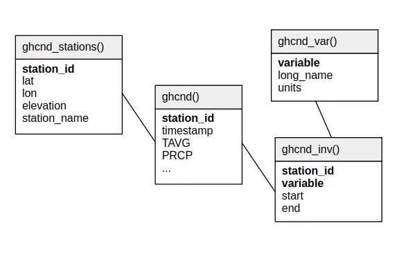
Relational schema#
Below is the relational schema of GHCNd in SEASTERS.
Variable overview#
Query:
SELECT *
FROM ghcnd_var()
ORDER BY variable
Response:
┌──────────┬──────────────────────────────────────────────────────┬────────────────────┐
│ variable │                      long_name                       │       units        │
│ varchar  │                       varchar                        │      varchar       │
├──────────┼──────────────────────────────────────────────────────┼────────────────────┤
│ ACMH     │ Average cloudiness midnight to midnight (manual)     │ %                  │
│ ACSH     │ Average cloudiness sunrise to sunset (manual)        │ %                  │
│ ADPT     │ Average Dew Point Temperature                        │ 0.1 degree Celsius │
│ ASLP     │ Average Sea Level Pressure                           │ hPa*10             │
│ ASTP     │ Average Station Level Pressure                       │ hPa*10             │
│ AWBT     │ Average Wet Bulb Temperature                         │ 0.1 degree Celsius │
│ AWND     │ Average daily wind speed                             │ 0.1 m/s            │
│ DAEV     │ Days included in multiday evaporation total (MDEV)   │ days               │
│ DAPR     │ Days included in multiday precipitation total (MDPR) │ days               │
│ DATN     │ Days included in multiday minimum temperature (MDTN) │ days               │
│ DATX     │ Days included in multiday maximum temperature (MDTX) │ days               │
│ DAWM     │ Days included in multiday wind movement (MDWM)       │ days               │
│ DWPR     │ Days with non-zero precipitation in MDPR             │ days               │
│ EVAP     │ Evaporation                                          │ 0.1 mm             │
│ FMTM     │ Time of fastest mile / fastest 1-minute wind         │ HHMM               │
│ MDEV     │ Multiday evaporation total                           │ 0.1 mm             │
│ MDPR     │ Multiday precipitation total                         │ 0.1 mm             │
│ MDTN     │ Multiday minimum temperature                         │ 0.1 degree Celsius │
│ MDTX     │ Multiday maximum temperature                         │ 0.1 degree Celsius │
│ MDWM     │ Multiday wind movement                               │ km                 │
│ MNPN     │ Daily minimum pan water temperature                  │ 0.1 degree Celsius │
│ MXPN     │ Daily maximum pan water temperature                  │ 0.1 degree Celsius │
│ PGTM     │ Peak gust time                                       │ HHMM               │
│ PRCP     │ Precipitation                                        │ 0.1 mm             │
│ PSUN     │ Daily percent of possible sunshine                   │ %                  │
│ RHAV     │ Average relative humidity                            │ %                  │
│ RHMN     │ Minimum relative humidity                            │ %                  │
│ RHMX     │ Maximum relative humidity                            │ %                  │
│ SNOW     │ Snowfall                                             │ mm                 │
│ SNWD     │ Snow depth                                           │ mm                 │
│ TAVG     │ Average daily temperature                            │ 0.1 degree Celsius │
│ THIC     │ Thickness of ice on water                            │ 0.1 mm             │
│ TMAX     │ Maximum temperature                                  │ 0.1 degree Celsius │
│ TMIN     │ Minimum temperature                                  │ 0.1 degree Celsius │
│ TOBS     │ Temperature at observation time                      │ 0.1 degree Celsius │
│ TSUN     │ Daily total sunshine                                 │ minutes            │
│ WDF1     │ Direction of fastest 1-minute wind                   │ degrees            │
│ WDF2     │ Direction of fastest 2-minute wind                   │ degrees            │
│ WDF5     │ Direction of fastest 5-second wind                   │ degrees            │
│ WDFG     │ Direction of peak wind gust                          │ degrees            │
│ WDFM     │ Fastest mile wind direction                          │ degrees            │
│ WDMV     │ 24-hour wind movement                                │ km                 │
│ WESD     │ Water equivalent of snow on the ground               │ 0.1 mm             │
│ WSF1     │ Fastest 1-minute wind speed                          │ 0.1 m/s            │
│ WSF2     │ Fastest 2-minute wind speed                          │ 0.1 m/s            │
│ WSF5     │ Fastest 5-second wind speed                          │ 0.1 m/s            │
│ WSFG     │ Peak gust wind speed                                 │ 0.1 m/s            │
│ WSFM     │ Fastest mile wind speed                              │ 0.1 m/s            │
│ WT01     │ Fog, ice fog, or freezing fog                        │ code               │
│ WT02     │ Heavy fog or heavy freezing fog                      │ code               │
│ WT03     │ Thunder                                              │ code               │
│ WT04     │ Ice pellets, sleet, snow pellets, or small hail      │ code               │
│ WT05     │ Hail                                                 │ code               │
│ WT06     │ Glaze or rime                                        │ code               │
│ WT07     │ Dust, volcanic ash, blowing dust/sand/obstruction    │ code               │
│ WT08     │ Smoke or haze                                        │ code               │
│ WT10     │ Tornado, waterspout, or funnel cloud                 │ code               │
│ WT11     │ High or damaging winds                               │ code               │
│ WT12     │ Blowing spray                                        │ code               │
│ WT13     │ Mist                                                 │ code               │
│ WT14     │ Drizzle                                              │ code               │
│ WT16     │ Rain                                                 │ code               │
│ WT17     │ Freezing rain                                        │ code               │
│ WT18     │ Snow, snow pellets, snow grains, or ice crystals     │ code               │
│ WT19     │ Unknown source of precipitation                      │ code               │
│ WT21     │ Ground fog                                           │ code               │
│ WV20     │ Rain or snow shower in the vicinity                  │ code               │
├──────────┴──────────────────────────────────────────────────────┴────────────────────┤
│ 67 rows                                                                    3 columns │
└──────────────────────────────────────────────────────────────────────────────────────┘
Important
Items of the variable column above are the fields (column names) of the main
table’s data records in ghcnd().
Attention
TAVG is computed in a variety of ways depending on the station. For some
stations for instance, TAVG points to a single daily measurement made at
traditional fixed hours of the day.
Station names and IDs#
Station IDs#
Station IDs are eleven-character long, in the following form:
FFNIIIIIIII
e.g., ASM00094299, where (the following is derived from GHCNd documentation):
FFis a 2 character FIPS 10-4 code indicating the territory (ASin the example, for “Australia”).Nis a 1 character “network” code indicating how to interpret the following eight characters (Min the example, indicating – refering to the table below – that the last five characters will make the station’s WMO ID). Below are the potential network code values with their meaning:Network code
Meaning
0
Unspecified (station identified by up to eight alphanumeric characters)
1
Community Collaborative Rain, Hail,and Snow (CoCoRaHS) based identification number. To ensure consistency with with GHCN Daily, all numbers in the original CoCoRaHS IDs have been left-filled to make them all four digits long. In addition, the characters
-and_have been removed to ensure that the IDs do not exceed 11 characters when preceded byUS1. For example, the CoCoRaHS IDAZ-MR-156becomesUS1AZMR0156in GHCN-DailyC
U.S. Cooperative Network identification number (last six characters of the GHCN-Daily ID)
E
Identification number used in the ECA&D non-blended dataset
M
World Meteorological Organization ID (last five characters of the GHCN-Daily ID)
N
Identification number used in data supplied by a National Meteorological or Hydrological Center
P
“Pre-Coop” (an internal identifier assigned by NCEI for station records collected prior to the establishment of the U.S. Weather Bureau and their management of the U.S. Cooperative (Coop) Observer Program
R
U.S. Interagency Remote Automatic Weather Station (RAWS) identifier
S
U.S. Natural Resources Conservation Service SNOwpack TELemtry (SNOTEL) station identifier
W
WBAN identification number (last five characters of the GHCN-Daily ID)
IIIIIIIIis the actual 8 character ID of the station, to be read based on the associated networkN(00094299in the example, meaning that, since the network code wasM, the first three zeros are to be ignored, and the last five characters constitude the WMO ID, i.e.,94299).
Tip
Such station ID formatting can be used to filter stations when loading data,
e.g., with SEASTERSdb
load_1h_gauge_data()
function. For instance, Indonesian stations could be selected using the following
filter_condition argument: filter_condition='station_id[:2] == "ID"'.
Station names#
Station names are formatted as follows:
<name> [US=<US state>, GSN=<GSN flag>, HCN=<HCN/CRN flag>, WMO=<WMO ID>]
where information between square brackets is not present for all stations. For instance,
the station with station_id='ASM00094299' has the following station_name:
WILLIS ISLAND [GSN=GSN, WMO=94299]
Below are explanations on the flags, derived from from GHCNd documentation:
<US state>is the U.S. postal code for the state (for U.S. stations only).<GSN flag>is a flag that indicates whether the station is part of the GCOS Surface Network (GSN). The flag is assigned by cross-referencing the number in the WMO ID field with the official list of GSN stations. The flag equalsGSNif the station is part of the network, and is blank otherwise.<HCN/CRN flag>is a flag that indicates whether the station is part of the U.S. Historical Climatology Network (HCN) or U.S. Climate Reference Network (CRN; also includes U.S. Regional Climate Network stations). The flag equalsHCNif the former,CRNif the latter, and is blank otherwise.<WMO ID>is the World Meteorological Organization (WMO) number for the station. If the station has no WMO number (or one has not yet been matched to this station), then the field is blank.
How to cite?#
This is GHCNd version 3.32, accessed April 9th, 2025. The documentation indicates to cite the dataset using Menne et al. (2012a,b).
References#
Imke Durre, Matthew J. Menne, Byron E. Gleason, Tamara G. Houston, and Russell S. Vose. Comprehensive Automated Quality Assurance of Daily Surface Observations. Journal of Applied Meteorology and Climatology, 49(8):1615–1633, 2010. doi:10.1175/2010JAMC2375.1.
Imke Durre, Matthew J. Menne, and Russell S. Vose. Strategies for Evaluating Quality Assurance Procedures. Journal of Applied Meteorology and Climatology, 47(6):1785–1791, 2008. doi:10.1175/2007JAMC1706.1.
M. J. Menne, I. Durre, S. Korzeniewski, S. McNeill, K. Thomas, X. Yin, S. Anthony, R. Ray, R. S. Vose, B. E. Gleason, and T. G. Houston. Global Historical Climatology Network - Daily (GHCN-Daily), Version 3.32. NOAA National Climatic Data Center, 2012. URL: https://doi.org/10.7289/V5D21VHZ (visited on 2025-04-09).
Matthew J. Menne, Imke Durre, Russell S. Vose, Byron E. Gleason, and Tamara G. Houston. An Overview of the Global Historical Climatology Network-Daily Database. Journal of Atmospheric and Oceanic Technology, 29(7):897–910, 2012. doi:10.1175/JTECH-D-11-00103.1.